|

|
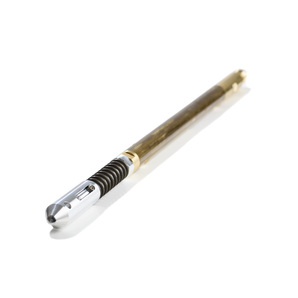
Based on modern MEMS technology :: The isCompass is a magnetic multishot instrument for borehole surveying based on modern MEMS technology. It is fully integrated in its own brass running gear, requiring little set-up in the field. Wireless in operation, the tool utilizes infrared communication with a rugged handheld field computer. isCompass is powered by standard C battery cells and will operate for more than 100 hours on seven batteries, which can be changed by the operator. Data is transferred from the handheld control unit to another computer using a standard USB memory. The system can be run in both single and multishot modes.
isCompass specifications :: The tool outputs standard survey data, such as recorded station depth, inclination, azimuth, gravity highside, magnetic toolface, temperature and more. The magnetometers have been calibrated with high precision and the tool will deliver a reading of the magnitude of the local magnetic field which can be used to detect anomalies in the local Earth magnetic field to identify survey stations of low quality. Local magnetic declination and start coordinates can also be set directly in the handheld unit. The OD of the fully-integrated running gear is 35 mm and the system is supplied with three aluminum extension rods to allow the operator to get the gear through and away from the drill bit.
isCompass - control and processing :: The isCompass is delivered with a rugged handheld computer, the Nautiz X5, running Windows Mobile 6.1. All operations and downloaded data are processed by the computer and can be viewed directly on the handheld device. Quality measurements of survey stations are also provided.
Multishot or Singleshot option :: The isCompass is available in multishot and singleshot versions.
isAnalysis - versatile analysis software :: Further analysis and data processing can be conducted using the isAnalysis software supplied with the system. The isAnalysis software can be installed on any Microsoft Windows XP , Windows 7 or Windows 8 (64 and 32 bit) platform and allows users to visualize, edit, correct, group and export their survey data. It can also import data from other surveying tools, Excel spreadsheets or text files. This allows easy addition of data from other tools and reference data to create a single exported spreadsheet.
| GMX isCompass Product Brochure 2016 English |
|
|
services |
products |
company |

|
GyroMax Pty Ltd | Tel: +61 429 900 279 | ABN 93 219 133 922 | ACN 150 891 035
Copyright© All rights reserved 2023 | www.gyromax.com.au
Copyright© All rights reserved 2023 | www.gyromax.com.au